Introduction
For this outdoor lab, myself and 4 other members of the UAS class were tasked with placing ground control points for a M600 flight. In an effort to test whether or not someone took good notes, we were given field notes of someone who was on a ground control point team from a previous mission and tasked with placing the ground control points in a better format. When placing ground control points, it is important to ensure that they are:
- Clear from tree coverage
- In adequate separation from one another
- Encompassing the parameters of the mission
- Accounting for various terrain
- Mapped out on a physical paper so that you can find them later
- Within eye-site of each other
- Turned on the moment before they are placed
- Kept running for at least 40 minutes to collect data
- Are numbered basted on their last 3 digit IDs
- Are collected in reverse order
 |
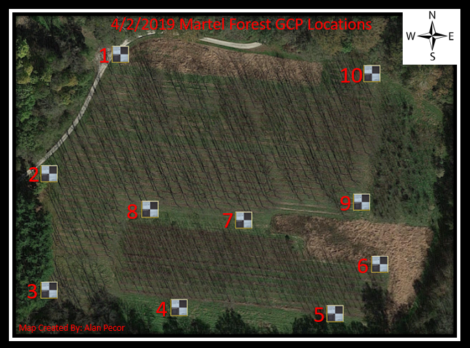
Figure 1: Martel Forest GCPs
Methods
Although I said I created map based on the watermark in the left hand corner, it is not technically a map since it doesn't have a scale bar. Nevertheless, this shows the Ground Control Point Locations from an aerial view. Below is a chart in Figure depicting the Ground Control Point order, the ID, and the location.
|
 |
| Figure 2: Ground Control Point Data |
DJI M600
The DJI Matrice 600 is an industrial UAV that weighs approximately 34lbs has a flight time of approximately 20 minutes and has triple redundant GPS units. As shown in figure 3, it is a hexacopter that appears a lot bigger in person and therefore is difficult to visually estimate in the air due to its size. The mission planning program used for this platform was pix4dcapure which is a free photogrammetric software.
 |
| Figure 3: DJI M600 |
Conclusion
As you will see in the video, the UAS was first tested in flight, and then autonomously taken over for the mission. Something that is important to note in the video is when the UAV goes to its way-points, Pix4D rotates it quickly in mid air. Although this enables an time saving and accurate flight, how do we know what orientation the UAV is when it is that high?


No comments:
Post a Comment