In airport operations, safety and efficiency enable credibility. This in turn enhances the development, prosperity, and international connectivity of the worldwide aviation system. Whether an airport is small or large, UAVs have and will impact airport activities as technology continues to evolve. Although in more recent news, UAVs have negatively impacted airport operations such as the Gatwick Heathrow and Newark insistence, these are due to non commercial UAV operations. While UAVs hold tremendous societal and economic benefits, occasional bad actors threaten to undermine the great progress that have made and even put responsible, legal ... operations in a negative light. (Butterworth-Hayes 2019). As of this post, there has not been a large commercial airport disruption due to a part 107 commercial operation.

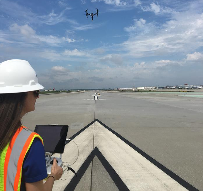
Figure 1: A DJI M600 Inspecting a Runway

Potential Benefits
Bolded is a short list of potential benefits that UAVs have on airport planning, construction, security, maintenance, and more. Although FAA regulations generally prohibit UAS operations near larger airports, careful pre-planning, careful coordination with appropriate airport officials and a certification of operation (COA) can persuade the FAA exempt certain UAS restrictions. To learn more about what a COA is and how it can help, refer to the FAA website.
Runway Integrity Surveys – UAVs have been used to provide 3D maps of runways in a very short space of time for routine maintenance to a very high accuracy level. Detecting problems with runway integrity at an early stage will lead to efficiency savings in the long-term.
Perimeter Security – UAVs have been used to provide support to airports by acting as a visual deterrent. As Demonstrated in Video 1, a tethered drone is in the sky and streaming to a control center which enhances the security of the airport during an airshow.
Executive security: According to securitymagazine.com, “If you have an executive protection team that’s operating in remote locations, they could potentially utilize a UAV to do forward observation of routes and to identify any potential issues that are en route while they’re driving their primaries around”-James Acevedo
Foreign Object Detection (FOD)– UAVs chave been used to provide the aerial detection of foreign objects, alleviating the need to shutdown a runway so that this can be done by eye (as is currently the practice) whilst freeing up valuable runway slots.
Building Surveys – Like runways, UAVs have been used to provide aerial surveys of terminal buildings for routine maintenance. This is much safer than sending people up ladders or using hoppers. More importantly, the time saved could be utilized for more important areas to focus on. Shown in Figure 2 is an orthomosiac of a terminal.
Collecting Local Weather Data- According to businessinsider.com, it might be possible for UAVs to collect local weather data in the future. Local weather patterns and trends can have a huge impact on the takeoff and landing of planes, which pilots often note can be the most dangerous part of the entire flight. With NASA already exploring unmanned aircraft to collect weather data, it's possible that UAVs on runways could be used in the future to collect similar data and then relay it to air traffic control.
Case Studies
Below are a few examples of airports utilizing UAVs to enhance airport operation, planning and maintenance.
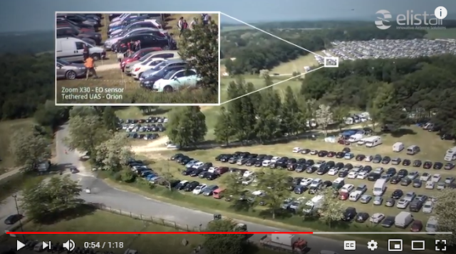 |
| Video 1: A UAV Monitoring an Airport for Security |
Foreign Object Detection (FOD)– UAVs chave been used to provide the aerial detection of foreign objects, alleviating the need to shutdown a runway so that this can be done by eye (as is currently the practice) whilst freeing up valuable runway slots.
Building Surveys – Like runways, UAVs have been used to provide aerial surveys of terminal buildings for routine maintenance. This is much safer than sending people up ladders or using hoppers. More importantly, the time saved could be utilized for more important areas to focus on. Shown in Figure 2 is an orthomosiac of a terminal.
 |
| Figure 2: Orthomosaic of Terminal |
Case Studies
Below are a few examples of airports utilizing UAVs to enhance airport operation, planning and maintenance.
Hartsfield-Jackson (aka Atlanta International Airport) serves more than 101 million passengers annually with nonstop service to more than 150 U.S. destinations and nearly 70 international destinations in more than 45 countries. Known as one of the busiest airports in the world, any construction, maintenance, or inspections to the airport can cause a risk in safety and a loss in revenue. Therefore, any operation that involves people obtaining imagery in high places in an allready conjested airspace is risky inefficient and expensive, As an alternative, UAVs such as the the Falcon 8, the 3Dr Robotics Solo and the DJI inspire 2 have been authorized to fly in ATL's Class B airspace. Shown in Figure 2 is a UAS pilot calibrating the Falcon 8 on international Runway 9L/27R.
 |
| Figure 3: Intel Falcon UAS and Pilot on Runway 9L/27R |
According to Michael Baker International, Runway 9L/27R is the longest runway of the airport and when flown, the UAV took 20 minutes to take 630 photos. When compared to the manual process, the UAV saved approximately 3 hours and 40 minutes. As a result, this method provided a large amount of data, a significant cost savings, and from an insurance standpoint, significantly less human liability risk. Once processed, the data collected from the UAV provided contours, orthomosaic imagery, RGB 3D textured mesh and a digital terrain model. The data was then analyzed by experts and airport teams using engineering software to help plan for present and future maintenance. Shown in Figure 4 is a UAS pilot flying a DJI Inspire over a different runway in Atlanta.
 |
| Figure 4: A UAS Pilot Flying a DJI Inspire Over a Different Atlanta Runway |
Luxembourg Airport (LUX) Geremany- According to Airsight, the UAVs have used to conduct a photographic documentation of the pavement conditions of all the airport aprons in LUX. The aim of the investigation was to support the determination of PCN (Pavement Classification Number) and each apron area was published in Aeronautical Information Publication (AIP). As a result, the UAV was able to deliver detailed input information of actual pavement conditions. Shown figure 4 are various forms of pavement deformation.
 |
| Figure 5: Various Pavement Deformations Detected by an Airsight UAV |
During each UAV flight segment, the camera mounted on the UAV took 300 to 500 individual images with an average resolution of 3mm per pixel. Within the data post-processing, an orthophoto (undistorted, rectified and geo-referenced image) was generated from the inspection images for each apron. These images are intended to be used for planning of future maintenance and rehabilitation works on the apron areas.
Paris–Le Bourget Airport-The Safe-T tethered drone system was utilized to perform maintenance on the airport’s Precision Approach Path Indicators (PAPI), which are blocks of four lights located beside landing runways that provide visual guidance information to pilots for acquiring and maintaining a safe and accurate glide slope on final approach. Placed perpendicular to the runway approach path, generally on the left side, each PAPI unit displays a row of lights emitting red light below a certain angle, and white light over a certain angle. Shown in the small box in Figure 5 is the teathered UAV. Shown in the larger box is its point of view and the PAPI indicator.
 |
| Figure 6: The Point of View Screen of a Tethered UAS |
In the video below is another application of the same tethered system but being utilized to inspect the gateways at CDG airport which is also in Paris France.
 |
| Video 2: A Tethered UAS Inspecting a Gateway ad CDG Airport |
 |
| Figure 7: Canard Unmanned Aerial Systems at Huesca-Pirineos Airport |
The results of the inspection were obtained in real time provided to the maintenance crew. In less than 48 hours, canard was able to provide the reviewed and signed reports. Although Poland's regulations are different from U.S. FAA regulations, this case is another example of how UAS can benefit Airports.
Conclusions
Although you will likely encounter negative themed news stories when you search online keywords such as drone and airport, there are a growing number of airports embracing UAS technology. Although these case studies were from larger airports, small airports will benefit from less expensive unmanned aerial systems when flown professionally. As UAS becomes more vital to the National Airspace System, can it survive in airport applications despite occurrences of amateur operator ignorance?
Reference
Butterworth-Hayes, P. (2019, April 30). AUVSI XPONENTIAL 2019 News - AUVSI and ACI-NA set up UAS airport mitigation task force. Retrieved May 18, 2019, from https://www.unmannedairspace.info/latest-news-and-information/auvsi-xponential-2019-news-auvsi-and-aci-na-set-up-uas-airport-mitigation-task-force/
No comments:
Post a Comment