Wednesday, October 2, 2019

Capstone Assignment 6: Why Unmanned Aerial Systems?

A standalone degree in Purdue University's Polytechnic Institute, Unmanned Aerial Systems (UAS) encompasses a multitude of subjects, skills, and activities that challenge students to maximize the applications, data, and relevance of UAV technology in a professional an innovative way. While balancing factors such as the rapidly changing business arena, consumer needs, and aviation law, this degree will produce cost effective solutions to problems that were once deemed impossible to address. In a "typical" UAS activity, I am expected to critically consider factors shown in Figure 1. Although Unmanned Aerial Systems can be both way more and way less complex depending on the operation, I am one of the few that get to directly engage in this type of workflow each day.
Figure 1: UAS Topics
With a combination of multimodal training approaches, research opportunities, and hands on field experience, I have earned presentation time slots at research conferences throughout the last two years. As part of the tradition, I am in charge of designing my own poster, but in the case of  preparing a poster for Purdue's GIS Day I also worked a team of 10 to create a Capstone poster in 2 hours. Shown below in Figure 2 is the PDF version of the Capstone poster which demonstrates the deliverables of UAS data specific to our department.  
Figure 2:  AT 409 Capstone Poster

Thursday, September 19, 2019

Airspace Explained from a UAS Perspective

Perhaps one of the most important yet constantly confused subjects in UAS, the U.S. National Airspace System is a fairly organized yet complicated network of active aircraft. Therefore, this post is an attempt clarify any misunderstandings about airspace by incorporating  videos, figures from the FAA, and text quoted from the  Pilots Handbook of Aeronautical Knowledge  (PHAK) which are linked accordingly.

Types of Airspace
Taken from the PHAK and the FAA AIM, the categories of airspace are: regulatory and non regulatory.
  • Regulatory airspace includes Restricted, Prohibited and various classes (Class A, B, C, D, and E) airspace- These are the areas where FAA regulations are in place.
  • Nonregulatory airspace includes MOAs (military operations area), warning areas, alert areas, and controlled firing areas.
Within these two categories, there are four types: controlled, uncontrolled, special use, and other
airspace. Shown in Figure 1 are graphics of airspace Class A-E. Below the figure is a breakdown of each airspace.
Figure 1: Airspace Diagram taken from faa.gov


Class A Airspace 
 Is the highest airspace and extends from 18,000 to 60,000 feet above mean sea level (MSL). Although it is extremely rare for UAS operations to take place here, systems such as the Global Hawk and Ikhana do. 
Class B Airspace
Generally encompass the busiest airports and can extend from the surface to 10,000 feet MSL. If you are planning to operate an sUAS in class B airspace, you must have at least one of the following:
  •  An airspace authorization from LAANC
  •  An airspace authorization from Dronezone
  • A specific FAA waiver
  • A well written COA   
Shown below is a short video taken from the FAA that explains how to identify class B airspace on a sectional chart.
                                                                                                                   
Video: Class B Airspace
Class C Airspace 
Surrounds area from the surface to 4,000 feet above airports that have an operational control tower. 
Although the configuration of each Class C area is individually tailored, the airspace usually consists of a surface area with a five NM radius, and an outer circle with a ten NM radius that extends from 1,200 feet to 4,000 feet above the airport elevation. If you are planning to operate an sUAS in class C airspace, you must have at least one of the following:
  •  An airspace authorization from LAANC
  •  An airspace authorization from Dronezone
  • A waiver
  • A well written COA   
Shown below is a short video taken from the FAA that explains how to identify class C airspace on a sectional chart.      
Video: Class C Airspace
Class D Airspace
 Extends from the surface to 2,500 feet at airports that have an operational control tower. Depending on the airport, some towers close which can cause the surrounding airspace to switch from class D to Class E. Therefore a UAS operator must make sure they know what airspace they are in the time of their operation. If you are planning to operate an sUAS in class D airspace, you must have at least one of the following:
  •  An airspace authorization from LAANC
  •  An airspace authorization from Dronezone
  • A well written COA
  • A waiver 
Shown below is a short video taken from the FAA that explains how to identify class D airspace on a sectional chart.
Video: Class D Airspace
Class E Airspace
This airspace can exist both around airports and above the ending of class G airspace. To better depict his, divide class E into categories.
  1. Class E Surface Airspace- this exists around airports starting at the surface.
    • If you are operating in surface class E airspace, you will need an airspace authorization from the FAA to fly. 
  2. Class E Outer Surface- this airspace exists away from airports and typically begins at 1,200 feet AGL
    • If you are operating in outside surface class E airspace, you do not need airspace authorization from the FAA to fly.
Shown below is a short video taken from the FAA that explains how to identify class E airspace on a sectional chart.  
Video: Class E Airspace
Furthermore, be aware where class E airspace ends and where class G airspace begins. Referring to Figure 2, airspace within the magenta circle indicates that class G airspace starts from the surface to 699 feet while class E airspace starts at 700 feet. Outside of the circle, class G airspace starts at the surface to 1,199 feet while class E airspace starts at 1,200 feet.
Figure 2: Class E Airspace
Class G Airspace
If you are not at in Class A-E airspace, or within a Restricted/Prohibited or Military airspace, you are likely in Class G airspace. Class G is Uncontrolled Airspace therefore you do not need FAA permission to fly. Shown below is a short video taken from the FAA that explains how to identify class E airspace on a sectional chart.
Video: Class G Airspace
Conclusion
Being able to identify airspace is vital to UAS operations. More often then not, numerous and perhaps infamous UAS related incidents have occurred simply because operators were unaware of the airspace that they were flying in. With the introduction of LAANC and changing FAA regulations, we will one day have to consider if an air traffic control system specific to UAVs will exist despite knowing the fact that an aircraft can land in close proximity to UAVs and vice versa. Nevertheless, having a solid understand of airspace will enhance your credibility as a professional UAS pilot. 

Wednesday, September 18, 2019

Parachute 101

In the upcoming week, I will be publishing a video on how to correctly fold a parachute for the C-Astral Bramor PPX. Since this is a fairly complicated process, I have spent days collecting data and working on ways to communicate the content in the most effective way. Since the C-Astral depends on using a parachute to land, it is essential that the training content is as clear and as informative as possible. To help better understand the components of the parachute, I modified a diagram taken from the C-Astral Bramor's online user manual, transcribed it into Microsoft Word and then saved as it as image for you to see below.

Friday, September 6, 2019

Capstone Assignment 5: Preparing for GIS Day November 7th

Overview
Taken from the Purdue GIS day website, Purdue Libraries hosts a GIS (Geographic Information Systems) Day celebration every November as a local component of a greater international event. In this context, “GIS,” is defined as a collection of software applications, hardware devices and data sensors, that have the capability to generate maps, statistical data, and digital mapping based upon  proprietary software and open-sourced workflow. As mentioned in Assignment 4, I am currently in the process of demonstrating how GIS can be applied to planning terrain intense missions with UAV systems such as the C-Astral Bramor PPX. Therefore, the purpose of this post is to provide you an update of discoveries I have made using a variety of tools from Esri Arc Pro.

The Need Proper Mission Planning
Throughout this Capstone Project, proper mission planning is vital to creating a safe and efficient UAS operation. In the context of planning missions in areas deemed difficult or inaccessible for humans, using GIS to plan UAS missions can save the client an immense amount of time and money before the UAS team arrives on sight. Why? Throughout my experiences operating UAS missions, there is usually an unknown variable that can cause the mission to take longer than the anticipated time. Wouldn't it be nice to mitigate most of the unknowns on a computer screen rather than climbing a mountain? 

The Tools I have Tested for Mission Planning
From an in the office mission planning perspective, I believe simple tools used in ArcGis Pro can help you determine issues such as learning elevation values, anticipating greater obstacles, and accounting for FAA Regulations. Although some of these items may be retrieved from Google Earth, ArcGIS Pro is the only software that can provide analysis of the environment without having to search different websites. To learn more, take a look the tools that I have used to combat common UAS related Problems. 

1) Classifying Terrain Values from A Clipped Raster.                                                                         The Problem: Depicted in Figure 1 are two areas of elevated terrain, from standing at Mountain A, you think that your UAV can fly directly over an area of interest at Mountain B. Aside from testing this theory on the field, how can you guarantee the UAV doesn't crash on the side of Mountain B?  
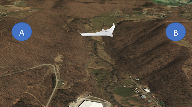
Figure 1: Can the UAV make it to Point B without Crashing?

The Solution: Classify the image to derive values from the Terrain. Depicted in Figure 2 (at a slightly different perspective) are values I could identify based on classification from a layer in a summarized elevation feature. Since the layer is from an Elevation Database, the height of the mountains are fairly accurate. Furthermore, the color coordination can help a mission planner instantly focous in an area of interest based on the needs of the mission rather than clicking on random points of the mountain to retive values.
 Figure 2: Classifying Elevation Values to Avoid Collition

2) Adding Layers from the USA hydrology database, the USA National Hydrology Database, and the World Terrain reference data base. 
The problem: Depicted in Figure 3 is a satellite image of a mountain without overlayed datasets. From a mission planning perspective, it be helpful to answer questions such as;
  • Where can I access the mountain via vehicle?
  • Do I have to worry about runoff that can be found in valleys?
  • Will I be flying over vehicles that can potentially interfere with FAA regulation Part 107.39?
Figure 3: Perspective Without Overlayed Data
The Solution: Thanks to overlaying the terrain with different databases, you can easily see access roads, a highway, and areas where water can interfere with mountain access and data collection. Figure 4 makes it significantly more easier determining answers to the questions in the problem. 
 Figure 4: Perspective With Multiple Datasets

3) Create Profile Views to enhance situational awareness and observer placement
    The Problem: Mission planning lacks data to analyze the terrain of a mountain. Using the Profile        Geoprocessing tool, you can create lines that can tell you the slope of the mountain at various              intervals. Depicted in Figure 5 are red profile lines numbered 1-4.    
Figure 5: Red Profile Lines 

The Profile lines can then be transcribed to a graph which can help a mission planner determine the various areas of clearance for both the drone and help visual observers know the easier and harder places to access the mountains. Below are the graphs calculated in reference from the profile lines. Notice how the mountain changes shape along with its elevation. *In future data collection, I will compute these values in a single graph. 
Figure 6: Profile 1 Graph


Figure 7: Profile 2 Graph

Figure 8: Profile 3 Graph

                                                                                  Figure 9: Profile 4 Graph

4) Use the Viewshed tool to estimate visual line of sight
    The Problem: Time and safety are compromised when a UAV cannot be found in the air.                      Wouldn't it be nice to estimate where to stand before you are on the field? Using the Viewshed             tool, you can troubleshoot and estimate optimal pilot and visual observer placement before you           climb a mountain to realize that trees are in the way.  Depicted in Figure 10 is a red point                      representing a person who is 5 foot 7 and can see up to 2,000 feet. If the same assumptions are            made with the Purple and Black point in Figure 11, who can see the mountain better?  
Figure 10: Location of Human at Red Point

With the Viewshed turned on, the Pink area depicts what the human could see at the given elevation  in Figure 11.
Figure 11: Estimated Area a Human Can See from Mountain Top

Across the river on the opposite side is the location of the human facing the mountain depicted by the purple and black dot in Figure 12. Demonstrated in Figure 13, notice the estimated greater amount of view the person has represented by the pink color

Figure 12: Location of Human Facing Bottom of Mountain

Figure 14: Estimated Area a Human can see from Bottom of Mountain

Tools that I want to Test for Mission Planning 
Currently I am working on a way overlay the layers I have created to the C-Astral Bramor PPX Mission Planning Software (C^2P3). If successful, I can perform a live simulation that will provide a crew customize perspectives to better understand the environment of their mission before they get to the field to operate. Therefore I have more work to do and mission planning can encompass more than the mission itself. For example, depicted in Figure 14 is an area where houses are located as well as what appears to be an area for power lines shown in the red oval. 

From a Public Relations standpoint, if you are engaging in a long term UAS operation for a community that is unfamiliar UAVs, wouldn't it be nice to send a courtesy letter to the houses you see below? If it is possible, I am going to attempt to explore GIS programs to see if its possible to gather the addresses of the the neighborhood. Furthermore, power-lines and cellphone towers can be hazardous to UAS operations so I hope to use Arc Pro to see if I can depict power sources or areas of high electromagnetic interference easier. 
  Figure 15: Neighborhood and Power lines
Conclusion 
It is obvious that GIS can have significant advantages to identifying and depicting important items in mission planning. In future posts, I plan to generate a map of an complex terrain mission and show how the data collected from the tools can help answer preplanning questions before the UAS team is deployed on the field. Furthermore I plan to exploit these resources create tutorials on how to use this software for UAS operations specific to the C-Astral Bramor PPX.

Capstone Assignment 4 Part 1: Putting Together an Introduction

Overview
As previous blog posts have noted, I am heavily invested in research for improving the safety of UAS operations. As the weeks progress, you will notice significant GIS applications that will be used to demonstrate training scenarios, mission planning, and aviation law, but for now, below is an early draft of an introduction to creating effective training content. 

Capstone Bibliography Introduction Draft
Training material for Unmanned Aerial Systems (UAS) is often vague, meticulous, and difficult for users to comprehend. Whether consulting difficult to read manuals, YouTube, or online discussion boards, striking a balance between establishing a clear and concise training process without sacrificing procedures vital to the safety of a UAS operation has been a reoccurring challenge that has proven costly to the UAS industry (Wyman 2019). As a result, poorly trained UAS personal have violated FAA regulations in the form of unauthorized flights, accidents, and lawsuits. 

According to UAS sightings report data produced by the FAA, manned aviation pilots submit more than 100 UAV sightings each month (UAS Sightings Report 2019). Although the sightings fail to clarify the type of UAS operation that occurred, airborne UAVs are not authorized to fly in the proximity of an active manned aircraft even if the manned aircraft are in the path of a UAV. Other examples of unauthorized flights include UAVs operating in airspace reserved for commercial aircraft, restricted airspace, prohibited areas, or areas with temporary flight restrictions. Referring to a United States database documenting UAV incident articles, there are numerous accounts of military, civilian, and Part 107 personal that have violated airspace regulations (World Wide Drone Incidents 2019).

In some cases, unauthorized flights lead to UAV accidents but in any case, UAV accidents tend to be a result of pilot error, lack of situational awareness, or poor mission planning assessments. This leads to the question, do you think UAS pilots have documented safety procedures in place to keep accountability for their actions? If so, are public, environmental, operator qualifications, crew resource management, and aviation law adjusted to suit to specific missions? Chances are, unless UAS operators are exposed to clear, concise, and free training material, how likely is it that the operators who need training content will pay for it let alone be able to comply with the rules of the National Airspace System?

From an aviation law standpoint, there are few free resources that address UAV related issues, and the most resources fail to stay up to date with current FAA regulations. As a result, UAV related lawsuits are on the rise (Consumer Safety Guide 2019). Although it is unclear what audience of UAV operators cause the lawsuits, one of the most costly was the result of a commercial UAS company flying UAVs in airspace without the correct authorization. Had the operators within the company been educated about airspace and aviation law, they could have easily avoided a 1.9-million-dollar suit from the FAA (Daileda 2017).

To combat the outcomes of poor training material, I must demonstrate, provide, and deliver free clear and concise training material from a smaller scale. Therefore, my first objective will be to create multimodal training content for specific UAS platforms, the C-Astral Bramor PPX and the DJI Matrice 600. After producing deliverables such as step by step how to videos, Power-points, Diagrams, and improved user manuals, my second objective will be to create a best practice training program that can be applied to commercial UAS systems defined by FAA part 107.

References
Daileda, C. (2017, January 18). The FAA just settled one of the biggest drone lawsuits ever.                            Retrieved September 5, 2019, from https://mashable.com/2017/01/18/huge-drone-lawsuit-settled/.

Drone Lawsuits on the Rise. (2019, May 21). Retrieved September 10, 2019, from                                             https://www.consumersafetyguide.com/news/drone-lawsuits-on-the-rise/.

FAA Aviation Safety Information Analysis and Sharing (ASIAS). (2014, September 14).                                    Retrieved September 15, 2019, from https://www.asias.faa.gov/apex/f?                                                  p=100:446:::NO:446::.

UAS Sightings Report. (2019, July 22). Retrieved September 9, 2019, from                                                         https://www.faa.gov/uas/resources/public_records/uas_sightings_report/.

World Wide Drone Incidents. (2019, January 1). Retrieved September 9, 2019, from                                           https://www.dedrone.com/resources/incidents/all.  

Wyman, O. (2018, October 15). Why The Use Of Drones Still Faces Big Regulatory Hurdles.                             Retrieved September 10, 2019, from                                                                                                        https://www.forbes.com/sites/oliverwyman/2018/09/10/why-the-use-of-drones-still-faces big-regulatory-hurdles/#7a6ff3451c0d. 

Capstone Assignment 4 Part 2:Creating an ArcGIS Story Map

Overview
In settings that require short missions with little terrain, google earth is often used as a go tool for in the office mission planning.  For my eventual presentation at Purdue's GIS Day, I am going to talk about GIS tools that can be used to preplan Missions for complex environments such as mountains. These tools can help you save time determining items such as sensor calibration, flight paths, visual observer placement, and other mission planning strategies that must be considered while fling in areas with challangeing tereain. For a sneak Peak, Click on the Link below and you will be directed to my ArcGIS Story Map. 

Thursday, September 5, 2019

Capstone Assignment 3: Digging in Deeper Using Online Databases


Overview
Throughout this week, I was tasked with creating an annotated bibliography for my capstone project which involves creating and improving training content for Unmanned Aerial Systems. Per instructions of the capstone project professor, I first had to collect data by selecting online databases and write a paragraph critique of each database. Shown in Figure 1 are the names of five databases encased in color coded icons that you see in the google slides. When you click on the names of the databases, you will be directed to a paragraph description of each database along with annotated sources and critiques of each source. 
Figure 2: Online Databases and Source Archive

Figure 2 depicts the keyword search process as well as the color coded search engines to easily distinguish the progression of general to specific material that I was able to gather. Due to the fact that commercial UAS is relatively new, finding articles explaining how to create meaningful training material was difficult to explore despite using the 5 different search engines shown in Figure 1. Nevertheless, I was able to use a combination of Ted talks, Research articles, and journal entries to help enhance my understanding on how to improve my methods in creating online training content
Figure 2: Online Database Keyword Progression
Training Tutorial Video 3 Critique 
The following video was recorded before I gathered sources for the annotated bibliography. Compared to Bramor PPX Tutorial 2, the language fluctuated less, and there were more sub-videos within the main video. In addition, the language sounded more confident rather than boring. Furthermore, this video is twice as long as Bramor PPX Tutorial 1 and Tutorial 2 but is less than 6 minutes. Despite having a longer recording time, the overall time it took to edit the video took me less time than creating Tutorial 1 and Tutorial 2.

In future videos, I will likely  create objectives or introduce content by identifying key components of a system before shoeing a demonstration. Since most of the sources I have read in the annotated bibliography suggested taking data from participants, I will attempt to send out questions to audiences that watch my videos. Furthermore, I will include more effects by using Camtasia studio to edit my content. Click on the video below to access the Battery Tutorial of the C-Astral Bramor PPX.
Bramor PPX Battery Tutorial 

Wednesday, September 4, 2019

UAS Volume Reservations

Perhaps a more recent acronym taken from the  FAA, a UAS Volume Reservation (UVR) appears to be a digitized notification to UAV pilots that permits priority operations to aircraft that impede areas that drones are operating in real time. Taken from the video that I have attached at the end, this new system resembles a TFR but unlike a TRR, a UVR can can appear with little warning. In fact the UVR is the warning that another aircraft is en route to the UAV's path. How is this possible? It appears that due to the Low Altitude Authorization Notification Capability (LAANC), registered UAVs can receive this real time information which can further increase the safety of our airspace. Shown in Figure 1 is a scenario of a medivac helicopter impeding  airspace occupied by 3 UAVs. 

Figure 1: Simulation of Medicvac Helicopter Impeding UAS Operations (taken from FAA video)

As progress continues to be made in creating a UAS traffic management system, it is clear that LAANC is experimenting with more concepts to help manage our airspace. Furthermore it is clear that the FAA is becoming more confident in enabling UAV pilots to determine whether or not Aircraft operations will force UAV pilots to land IF a UAV pilot determines that the UVR does not affect them. Click on the video below to see how UVRs may one day become standard in UAS operations. 
Video: Unmanned Traffic Management Demonstrations

Unmanned Traffic Management System Demonstrations

Unmanned Traffic Management System Demonstrations

Monday, August 26, 2019

Capstone Assignment 1: Drafting a Timeline

Overview 
Training material for Unmanned Aerial Systems (UAS) is often vague, meticulous, and difficult for users to comprehend. Whether consulting manuals, YouTube, or online discussion boards, striking a balance between establishing a clear and concise training process without sacrificing procedures vital to the safety of a UAS operation has been a reoccurring challenge that few have been able to address. As a result, poorly trained UAS personal have violated FAA regulations resulting in close calls, accidents, property damage, and lawsuits.

For this capstone project, my role is to combat the lack of clarity in procedures that must be emphasized in UAS missions. Deliverables from this research will include multi-modal training material starting with specific components of the C-Astral Bramor PPX. Throughout the aggressive project timeline shown in the PowerPoint in Figure 1, I will adapt best training practices that I discover to other Unmanned Aerial Systems platforms as well. Furthermore, I will explain important data collection principles one must practice in different mission planning settings.

Figure 1: Capstone Project Timeline
Project Parameters
Since the projects that I will be working  depend on the availability of the UAS systems, the availability of renting video equipment, the weather, and the amount of lab time I have per day, the schedule is designed to be relatively flexible. Although each task has an associated completion date, I can easily adjust it to accommodate to more tasks or allocate time to explain complicated tasks more thoroughly. Nevertheless, this capstone will produce weekly blog posts highlighting the progress I have made for you to see how much work it takes to design a clear and concise training video.

Equipment that will be utilized in creating the training material content will involve Camtasia, Purdue's video express videos, adobe suite,  Esri products, Microsoft office, and Pix4D. Shown in Figure 2 is a snapshot of myself in front of the Purdue video express reading off a teleprompter with content I created for the first training video. Shown in Figure 2 is the interface for Camtasia video studio and how I have been able to successfully incorporate both systems to produce the video that you see in.

First Training Tutorial
Similar to trouble shooting a UAS, troubleshooting media equipment was an activity I engaged with for 3 hours before I produced the first video. Never is it supposed to take as long as it did! Due to a technical issue involving  Purdue's online video database I had to wait on customer service for the majority of the trouble shooting time. During this process I gathered snapshots of the studio that I recorded the first training tutorial in. Shown in Figure 2 is myself in front of the teleprompter and operating the equipment in front of the green screen.

Figure 2: Me Operating the Studio Equipment

After a few takes, I provided a short clip with relatively few errors. In the past, users of the Bramor had no structured way of acquainting themselves with the C-Astral Bramor PPX unless the professor was present. Now the professor can have the users watch the first tutorial video prior to their hands on training session with the professor. Along with a modified training manual that I am creating, the video enhances safety because the students have easy access to information that they can cross reference as they begin to familiarize themselves with a complex system.
Video: Bramor PPX Tutorial 1
Training Tutorial Critique
Although the expectations for the first training video were very low, my expectations to improve the material in future videos are very high. Therefore, I will be doing extensive research in how to properly act when using a teleprompter and how to appear less robotic while using the video equipment. Furthermore, I will ask users for constructive feedback to see if there is anything else I can do to help articulate my dialogue in the most effective way possible. Furthermore, I will consider using more eloquent word choice when necessary. 

Thursday, July 18, 2019

Elios Confined Space UAS Inspection

Perhaps one of the more unique Unmanned Aerial Systems in the market, the Flyability Elios 1 is  a confined space inspection UAS that originates from Switzerland. Therefore, I was extremely fortunate to operate this system for a brief time during my internship at Crawford Murphy and Tilley. With permission from the company I was able to make a post about the process we underwent to pull off another successful UAS confined space inspection mission. Shown in the video below is an idea of what its like to operate the Elios UAV. Although I do a good job at getting it close to my stationary camera, I am constantly adding in inputs to the transmitter because this UAS has no means of localization.

Overview
Designed with a distinguished spherical carbon fiber cage, the Elios 1 is a fairly sophisticated confined space inspection UAS. Key features include but are not limited to:

Collision Tolerant Resistance
High Effiecney on Board LED Lighting
Thermal Sensor
A flexible Sensor
Wireless Communication in Confined Spaces

Familiar to most, the ground control station uses DJI software but unlike most, the Elios 1 does not handle like a DJI UAS. This is because it has no means of localization. In fact, it takes a considerable amount of skill to keep the UAV stable in flight. Nevertheless, this system can navigate through areas inaccessible to humans and can keep people out of danger.

Preplanning the Mission
Given the fact that the Elios has proven to be a cost effective alternative to relatively time consuming confined space inspection, we determined that the Elios was the best tool to examine an out of commission elevator shaft at a wastewater treatment facility. Although easier said than done, the decision to use the Elios was a result of data from experts familiar with the work site, a risk assessment matrix, and a scope of the elevator shaft. From that point we had two options:
  • Purchase the Elios 1 for $35,000
  • Consult MFE Rentals and receive a quote for a three day operation
In this scenario, second option was the most economically feasible so we confirmed a three day rental. Day 1 was dedicated to getting antiquated with the Elios and familiarize ourselves with the equipment. This included
  •  An inventory of all Elios equipment
  • An assessment of the aircraft for any damage from delivery
  • Charging the batteries 
  • Practice Checking battery Voltage
  • Practice Performing battery changes
  • Practice flying the UAS
To give you an idea of the entire Elios system, refer to Figure 1 and the list of its components below. 

Figure 1: Elios UAS Case
  1. Battery Charger
  2. Android Tablett
  3. Tool Box
  4. USB tranmitter to tablet connecter
  5. Transmitter
  6. Backup Charger Chord
  7. Battery Pouch
  8. Lense Brush
  9. Battery Charger
  10. Cage to Frame Strap
As equally important to our preparation of the UAS, we had to remember that risk mitigation goes beyond the likelihood of a drone accident occurring. For example. How do we insure human does not get hurt accessing the work-site? Taken from the Flyability website are three important resources that we utilized. 
Emphasized throughout these resources, it was vital that we pre-plan for potential safety hazards. This means that we made sure to pack personal protective equipment including.
  • Hard hats
  • Safety goggles
  • Steel toe boots
Furthermore, having an environmental awareness was key. For example, as we began our mission on Day 2, the entrance to the area was poorly lit and we had to enter through a this door shown in Figure 2.  Had we not prepared items such as flashlights, crowbars, and gloves, our mission would have taken significantly more longer.

Elios Flight Experience
After turning on the system, going through the checklists, and performing a test flight, we conducted the Elios confined Space inspection mission. Although I am not allowed to share the videoor the photos of the Elios in the elevator shaft, we were able to provide video and thermal imagery to the client. Totaling less than 24 minutes of flight time, we spent more time planning the mission then performing it. Although I have no idea how much time a human inspection would take, or how many hazards would have to be mitigated, I imagine that the Elios inspection was a preferred alternative compared to  hiring certified climbers. 

Conclusion
After the mission, processing the data was relatively straightforward, and the resources from myflyability.com have a great workflow on how to analyze the thermal imagery. Within the same day we were able to provide the client the Elios inspection results so that engineers could determine a cost effective solution on how to address the elevator shaft. In addition I flew a UAV on the exterior of the building to give the clients a clear perspective of areas they might have to address for future repairs.

Tuesday, July 16, 2019

Flying the Elios 1

In an upcoming post, I will share my experiences assisting in a confined space inspection with a fairly unique Unmanned Aerial System called the Elios 1 by Flyability. Costing nearly $35,000, this sUAS is a non traditional but innovative tool for industries that require inspections in hazardous areas. Although I am currently occupied with other sUAS activities, I will never forget the experinces I've had with machine. Stay tuned! 

Elios 1 sUAS