In this scenario a client wants you to collect aerial imagery of flooding along the Weber River depicted in Figure 2. What items should be considered as you use GIS to preplan this mission?
Figure 2: Weber River Proposed Area of Operation
Although there appears to be several areas for a UAV to operate, it is vital that you check the airspace. Using the Portal function in ArcGIS Pro, you can import a file called FAA sectional Chart Data and overlay it to the proposed area of operation depicted in Figure 3.
Figure 3:Weber River Overlay with FAA Sectional Chart Data
Indicated by the red Star, the proposed area of operation is within Class Delta Controlled Airspace. When referring to FAA Part 107.41 it is vital that you receive permission to fly in this airspace because of the blue dashed lines and the two airports within the proximity of the proposed area of operation. After discovering that you are in Class Delta Airspace, you will now have to figure out how to receive permission from air traffic control to safely fly within the airspace.
Another Feature that you can import form the Portal of ArcGIS Pro is the Low Altitude and Notification Capability (aka LAANC) Data. LAANC is a software that can be utilized to automatically receive permission to fly a UAS in near real time. Depicted in Figure 4 is what LAANC data looks like after imported as a File called FAA_UAS_FacilityMap_Data. Focusing on the box around the star, you can click on this data to open a window which shows the maximum elevation you are allowed to operate your UAV at. In this specific area, the maximum elevation is 0 so in order to operate in this area legally, you will have to acquire a certified of authorization (COA) to operate a UAV in this area. Within the same pop up, you can access the airport’s name which you can then contact to begin the COA process.
Figure 4: LAANC Data Derived from Arcgis Pro
Scenario 2
Referring to Figure 5, your area of interest and your UAV launch site are divided by a road. Focusing on this division before you arrive to the proposed area of operation, platforms such as Esri ArcGIS Pro can help understand traffic conditions near the launch site. If the road does not have a lot of traffic, it is possible that you can have the UAV cross the road without violating FAA Part 107.39. If the road does have a lot of traffic, you might want to consider a different launch site.
Figure 5: UAS Operation Across Road
Furthermore, ArcGIS Pro has the ability to visualize traffic in real time which could help you plan the trip to the mission as well as determine times of day where traffic is slow. Depicted in Figure 6 is a World Traffic Surface raster I added with the data. Combined with adding a world street map, I found that the name of the road is US Route 310 and at the time I added the raster, there was heavy traffic going both ways.
Figure 6: Esri Arc Pro Predicting Heavy Traffic
Scenario 3
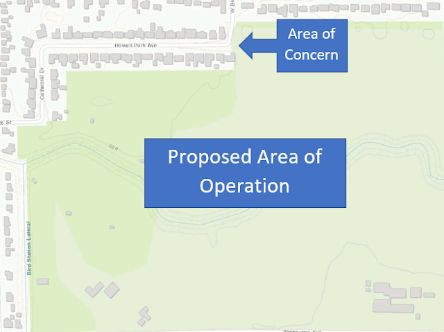
Before the introduction of Part 107, a recreational UAV crashed causing property damage near a house within a small community. Despite having no association to this incident, you the community has expressed concern after hearing about a proposed terrain analysis operation in the area you see in Figure 7. Using Arc Gis Pro, what tool can you use to assist your company in convincing the community that this proposed operation is safe?
Figure 7: Focusing on a Neighborhood with a Negative UAS Perception
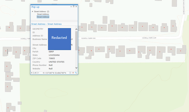
Depicted in Figure 8 is a layer you can obtain from the portal section of ArcGIS Pro. When you click on the houses, you can obtain address information. Address information could enable you to send the community data supporting your company’s values of transparency, ethics, and safety before the proposed UAV operation. This can enhance your credibility as an aviation professional as well as potentially attract new clients. Likewise, I purposely redacted the address I found to keep those people's information private. Although I am still learning to geocode housing data of this website, I believe that you can import it from online data sources or find it deep within the portal section of ArcGis Pro.

Figure 8: Obtaining Housing Addresses to Notify Community About UAV Operation
Scenario 4
To reduce the workload of the visual observers that you employ for a UAV operation on a mountain, you are asked to figure out optimal locations that they spectate in order to maintain eye contact with the UAV (As required in FAA part 107.31). In this scenario, you can utilize the line of site tool in ArcGIS Pro to troubleshoot, estimate, and place visual observers which can reduce the amount of overall field time. Unlike the viewshed tool, the line of site tool can depict the specific direction one has towards a floating object such as a UAV. Depicted in Figure 9 is an estimate of a visual observer's perspective from a UAV that was set to a distance of 1,000 feet away and 350 feet above ground level.
Figure 9: Utilizing the Line of Site Tool in ArcGIS Pro
Scenario 5
The final scenario in this post and a key deliverable of my report, this mission is currently being tested and includes exporting data from Esri Arc Pro to mission planning software for the C-Astral Bramor PPX. If done correctly, accurate, up to date geospatial data can be added to the Bramor which will enable it to have a safer and more efficient flight in terrain induced environments. Depicted in Figure 10 is a screenshot of the simulated mission scenario so far. In the upcoming weeks, my goal is to demonstrated a fully simulated mission with the Bramor PPX flying over geospatial Data processed in Arc Pro.
Figure 10: Perspective Taken From C'astral's Mission Planning Software


No comments:
Post a Comment