Monday, January 2, 2023

How Enterprise UAS Offer Value to Civil Engineering Projects

Overview                                                                           Contents in the following poster highlight a few practical applications offered using commercial enterprise Unmanned Aerial Systems (UAS) for civil engineering specific projects. The poster is picture heavy because it is intended to be blown up and used as a background for in person demonstrations because the pictures serve as excellent visual cues and talking points. Unlike most research posters, this was created entirely from data collected by USI Consultants and put together by myself.  By clicking on the pdf, you can zoom in to read more about why we use UAS for certain applications, and how UAS adds value to projects and ultimately the people in need of solutions.

 Click the Pop-out Icon on the top Right Corner to Enlarge this PDF

Friday, December 23, 2022

Happy Holidays From USI

                                                See Alan Cry and Then Have to Get Back to Work 

Oh boy, looks like the marketing team decided to spice things up for the holidays! Instead of the usual holiday stuff, they came up with a brilliant idea: have our brave colleagues taste some fiery hot sauce and film their hilarious reactions!I was one of the unfortunate souls who took on this hot challenge. Let me tell you, I felt like i was conbusting in the inside! I mean, I can barely handle a flaming hot Cheeto, let alone a sauce with the following stats:

 Figure 1: Sauce Stats

Wednesday, November 16, 2022

Can UAS Themal Data Add Value to Bridge Inspections?

Overview

Many know that thermal equipped UAS are useful for infrastructure inspections, but few know how they add value compared to traditional inspection methods. In the case of concrete deck inspections, thermal equipped UAS can be an extremely valuable tool because the collected data can expose deficiencies often invisible to the naked eye. I am not going to spell out how exactly this translates into cost savings, but the value can be in the tens of millions depending on the structure scanned.

Secret Hints About UAS Thermal Ops 

From a deliverable standpoint, the product is a preventative maintenance plan. To get to that point, be prepared for a big investment in a specific thermal camera, take more than one thermography training and have design and structural engineers in your office. If you get that far, make sure your thermal imagery has visual reference imagery, invest heavily in computer software, and make sure you have the aircraft and camera settings dialed in.

Oh yeah, make sure you can legally the area of interest in the first place!  At this point, I have provided more than enough hints about how thermal offers value to concrete bridge deck inspections including the document below that I created with USI Consultants. If you have any questions, please reach out to me directly.  


 Click the Pop-out Icon on the top Right Corner to Enlarge this PDF

Sunday, September 4, 2022

What The XT2 Can Do For You

Overview

Taken from DJI’s Website, the Zenmuse XT2 is a side by side visual and thermal sensor that allows us to pick up thermal energy emitted from a surface. Depicted in Figure 1, this camera is compatible with the DJI Matrice 200 and 300 series and offers a plethora of capabilities including live heat tracking, temperature alarm, isotherm measurements, etc..., 

Figure 1: Diagram of XT2 Sensor by DJI 

How XT2 Video Offers Value to Inspections

 In the case of bridge deck inspections, side by side visual and thermal video can be extremely useful in gathering preliminary data about the condition of a bridge deck. If you click on Figure 2, you will be directed to a YouTube Video I captured which shows the video recorded from the XT2 looking straight down at the bridge deck. Credit to USI Consultants for allowing me to share this video. 

Figure 2: Link to Example Video 

Why is Properly Formatted XT2 Video Important? 

For the sake of not giving away all our secrets, I will answer this question vaguely. Overall, videos created in this format allow us to see EXPLOIT INVISIBLE DEFFICINCIES quickly. Is this the most perfect accurate way to assess a bridge deck condition, no because there is so much more that can be analyzed from Radiometric JPEGs that can be captured by the XT2. However, for a 10-minute flight, video from the XT2 significantly reduces fieldwork. 

Are There Cons to Recordings Taken from the XT2?

Yes, since the XT2 is two cameras in 1 sensor, the frame rate and the frame sizes need to be scaled and trimmed with fairly expensive video editing software. This limitation can be addressed with a solid QC/QA program and thermography training.  Thermography training is also vital to the mission planning and further data analysis which can be done with additional UAS software that I will not go into detail in this post. 

Conclusion

Knowing how to use the XT2 and the thermography software needed to edit and, understand and in some cases interpret deficiencies is vital to successful bridge deck inspections. If you have any questions about our workflow we would be happy to share with you more information. Please reach out to USI Consultants by clicking on Figure 3 below. 

Figure 3: Link to USI Consultants Website

Tuesday, May 10, 2022

UAS and Stormwater Applications

Overview

Local, state, and federal agencies have utilized UAS for items such as stormwater management, environmental compliance, and safety inspections. From a general documentation perspective, UAS is a tool that can provide reliable and repeatable observations which (when processed correctly) can easily show changes of subjects over time. Rather than list the multitude of applications UAS offers to stormwater asset management, the following YouTube video does a good pretty job highlighting practical value derived from UAS services. Note: the first 20 minutes are useful, the last 20 minutes are not related to stormwater.  

See Practical UAS Stormwater Applications Here

Bonus Content 

Below is a flyer I created demonstrating how using photogrammetric mapping can allow end users to monitor stormwater assets that are new, missing, or yet to be geotagged. In the case of deveopling communities, areas with heavy construction, or areas impacted by natural disasters, you would be suprised to learn how many stormwater assets become "rediscovered" from UAS imagery alone. Using engineering and GIS software, a high resolution georeferenced digitized map delivered from UAS  becomes vital to future planning and deveoplement because it greatly reduces site visits, misjudgement and ambiguity. 
 Click the Pop-out Icon on the top Right Corner to Enlarge this PDF

Tuesday, December 14, 2021

Calculate Assets Rapidly With sUAS Technology

Overview

By creating a workflow involving strategic mission planning, fairly sophisticated UAS remote sensors, photogrammetric software, and data analysists, we have the ability to provide estimates for the total volume of an asset (or multiple assets) significantly quicker than traditional methods. To be blunt about this subject, many UAS people with photogrammetry software can estimate a volume with various degrees of confidence, but at USI we have a QC/QA program that can provide more confidence in our findings to ensure the information we provide is specific to the unique parameters of the mission and each invividual client expectations. Linked below is a PDF that showcases some of the projects I have flown and the services we offer at USI Consultants.


 Click the Pop-out Icon on the top Right Corner to Enlarge this PDF

Thursday, May 28, 2020

Creating Animations to Visualize Changes in Assets

Overview                                                                                                                                        Approximately my 2nd Commercial UAS flight working at USI Consultants, I was tasked with flying a photogrammetry mission to compare changes in earthwork for a project located in Hamilton County Indiana.  Since employees were nice to me being the “new guy”, I used a previous successful mission as a template and tweaked some of the settings to fine tune the specific parameters of the mission I was tasked with flying. 

Unique Mission Variables                                                                                                  During this time, Covid-19 was at its peak, and it was significantly more contagious because there were no vaccinations to prevent the spread. Nevertheless, we wanted to show the client the changes from our touchless assessments as well as deliver them a quantity for the earthwork they moved. 

Opportunity to Showcase Video Animations                              Video animations have their place for marketing purposes but are typically not worth the time making for engineering projects. However, in this case, we had four elements that made this project unique. 

  1.  A previous flight with that captured the same subject
  2. The ability to use animation trajectories from photogrammetry software
  3. The need to visualize a change 
  4. The need to provide a quantity 

As a result, I created a side by side video animation that could be shared with everyone needed to see the site changes which ultimately saved time, lowered cost, and in this case eliminated the need for unnecessary exposure to Covid….One might argue that Covid exposure is low when being outside since this was an outdoor project, but imagine if a crew had to stop to get gas on the way to the site or needed to take 5 additional vehicles….could the exposure risk be exposed? Would the travel cost be reasonable still? Below is the link to the animation with the mentioned elements. 

Video: Stockpile Animation Generated from UAS Data

Wednesday, November 20, 2019

Trip To Tanzania

Overview 
A few months ago, I was selected to by a sustainable volunteer program to travel to Tanzania Africa this December. In preparation for the trip, I have been learning about the culture, the laws, and the travel requirements that I will have to adhere to during my adventure. Since I am a UAS student, I am particularly interested in how Tanzania is using UAVs to serve it’s people. Therefore, this post is about Tanzania’s UAS applications.

Table of Contents
Part 1---------------------------------------------------------------------------------------------------Fighting Malaria with UAS
Part 2--------------------------------------------------------------------------------------------------Delivering Blood with UAS
Part 3------------------------------------------------------------------------------------------Intercepting Poachers with UAS
Part 4----------------------------------------------------------Utilizing Local Resources to Construct a UAV Airframe
Part 5-------------------------------------------------------------------------------------------------------Tanzania Aviation Law
Part 6-----------------------------------------------------------------------------------------------------------------------Conclusion

Fighting Malaria with UAS
Depicted in Figure 2 is a DJI Agras MG1-S spray UAV in Cheju, Tanzania. Taken from an article in Forbes Magazine, this specialized platform is designed to fight malaria which is responsible for killing 80,000 people per year. according to malariaspot.org. As being considered one of the first UAS based biological control applications in the world, could a UAS with operating limitations make a faster more cost-effective spray then manual spraying efforts?  For more information, click on the figure to be directed to the article.

Delivering Blood With UAS
Sounding more like a vampire program than a UAS program, a UAS collaboration consisting of Wingcopter, DHL, and the Deutache Gesellschaft fur Internationale Zusammenarbit (GIZ) have utilized a vertical take off and landing platforms (VTOL) to deliver blood and medical supplies to difficult to reach areas in Tanzania. Similar to efforts taken by Zipline, this method of UAS operation can help doctors save lives because instead of taking 4 hours to transport medical supplies, a Wingcopter can make the delivery in 20 minutes. To learn more, click on Figure 3 and you will be directed to their promotional video. Within it, notice how the doctors appear to be holding a transmitter upon landing of the aircraft. Why do you think they are doing that?
Figure 2: Link to DHL Wingcopter Video

Intercepting Poachers With UAS.
Taken from Drone blog.com, Tanzania has an anti-poaching initiative that involves flying UAVs over national parks, reserves and other protected areas to help security track and intercept poachers. Depicted in Figure 5 is Super Bat Da 50 UAS in front of the UAS crew and security personal. A product by Bathawk Recon this system can not only stay in the air for 8 hours, but it has several  sensors that claim to be able to easily track poachers before they arrive to the animal heards. Could this be an effective tool to combat poaching? Or is this another example of overrated technology taking advantage of Africa?
Figure 3: Superbat Da 50UAS 
Utilizing Local Resources for UAV Airframes
Taken from spectrum.com, Figure's 4 and 5 depicts Bornlove Ntikha using bamboo for the frame of his DIY UAV. Ntikha wants to show that UAVs can be built out of locally available materials which can help others learn how to construct UAVs themselves. Although this technology still requires a motherboard, a transmitter, batteries, and motor components, it is remarkable to see this take flight. If a sensor can be integrated to this platform and the UAV can be programmed to fly autonomously, nobody will care about the type of airframe as long as the UAS can perform missions safely and produce deliverables. Could this method of constructing UAVs be applied to more local Tanzanian UAS projects?
Figure 4: Bornlove Ntikha Working on a DIY UAV Using Local Resources
Tanzania Aviation Law
I am not an expert on Tanzania’s aviation law, nor am I an expert on how to interpret it, however if you are curious to see what UAS policy’s I have created a bullet list of Tanzania’s UAS laws that I could find online. In other words when regarding flying in Tanzania, you should consider the following:
  • UAVs weighing Unser 15.5 lbs do not require a permit to fly
  • UAVs weighing over 15.5 lbs require a special permit from the Ministry of Defense
  • UAVs require insurance no matter recreational or commercial operation
Furthermore, according to drone traveler.com, Tanzania categorizes UAVs by weight and by purpose:
  • Class 1: 0-11lbs
  • Class 2: 11 – 55lbs
  • Class 3: 55 lbs and more
Interestingly enough, it appears that there are also categories of operation as listed:
  • Category 1: leisure and sport
  • Category 2: private use except leisure and sport
  • Category 3: commercial use
Within operation category 2 and 3, it is my understanding that UAS operators must have a pilot’s license and be 21 years or older.  If you are someone that wants to bring your UAV into Tanzania to fly, the TCAA appears to accept Part 107 licenses as an acceptable means of documentation, but you will have to do a fairly significant amount of preplanning and communication with the TCAA before you lift off. Furthermore, it appears that you will need to pay of $200 as well. Nevertheless, it is very interesting to learn about UAS law in a different country. This makes me wonder what kind of rules UAS operaters coming to our country must abide by. Lastly, Tanzanian UAS resources can be found here:

Conclusion
Although it each UAS application in Tanzania is powerful, interesting, and can hopefully benefit the greater good, I favor Nikha’s story the most because he is an example of Tanzania’s self sufficiency as it will hopefully be able to one day create UAS technology rather than contract out to other countries. Nevertheless, each article as well as the Tanzanian government’s efforts to regulate the UAS operations within the country demonstrate that UAS has the potential to grow in Tanzania.Gif of Bornlove Ntikha and his DIY drone.
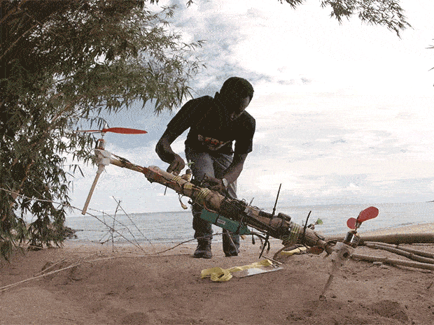
Figure 5: Bornlove Ntikha Assembling his DIY UAV

Thursday, November 7, 2019

GIS Day Results

Overview
As mentioned in previous posts, Purdue’s 11th annual GIS Day took place at Purdue’s Stewart Center on Thursday November 7th and featured a variety or subject matter experts from local, state, and federal companies. For roughly eight hours, I spent my time either presenting, questioning, or listening to a variety of people talk about their backgrounds in GIS and noted what deliverables they have been able to produce as well as learning why their deliverables were considered cost effective.To help further promote the UAS presence in GIS applications, I volunteered to present in front of an audience as well as enter a poster competition. Despite being my first-time attending GIS day, as well as being the only independent researcher, I earned second place in the Poster competition as shown inn Figure 1.
Figure 1: Myself (Right) Earning 2nd Place for Purdue's GIS Day Poster Presentation 
Key Takeaways
The material that I learned from this conference ranges from using GIS to survey census data to using GIS as a tool to survey erosion. In an effort to keep this content UAS related, I felt particularly interested in a presentation by Dr. Carly Sakamura from Maxar Technologies. Although this blog post fails to describe the amount of information in her presentation, she provided a unique perspective of showcasing the interest of the satellite data, and the challenges that the Maxar experiences when mapping the planet.

Although Unmanned Aerial Systems differ greatly from satellites, I was able to relate to her emphasis on the importance of collecting and interpreting accurate data let alone the data collection storage challenges that Maxar had to address. From a privacy standpoint, I found it fascinating that although satellite imagery cannot expose more than 30-centimeter accuracy, it is not because the technology cannot rather it is because the government “will not allow it”. This  leads me to reflect and believe that below 30-centimeter accuracy satellite data exists, but not for the general public.

Without harping on the above statement too much, I wonder how UAS mapping will accommodate national security interests, let alone who will be able to legally obtain highly accurate UAS data given the fact that UAS data a has potential to redefine the way we see the world. Will accurate UAS data produce the same challenges that below 30 meter satellite accuracy does? Or will the technology one day enable people to inexpensively purchase a UAV that can compete with satellite data?

Critiques and Conclusion
From a career development standpoint, I will be sure to go out of my way to participate in further GIS Day Conferences. Although my overall GIS day experience at Purdue was extremely meaningful, I hope that I can participate in future GIS day conferences where sensor specific subjects are discussed more openly. Due to the fact that I currently work with a variety of different sensors with a plethora of different applications, I think that learning about the sensors used to collect data can greatly improve my lexicon of factors to consider while planning UAS missions.

Furthermore, I hope to make it a priority to explore more open sourced software because not only is it free, open sourced software can provide solutions to problems that could otherwise cost thousands of dollars in licensing. Taken learn.g2.com, clicking on Figure 2 is a lexicon of 10 free different open source websites to consider. It looks like I will be starting there…
Figure 2: Access to learn2.com

Wednesday, October 30, 2019

Where Are My Pants?

Below is a snapshot of a forested area taken from a Sony RX1 sensor. Without scrolling down to the answer, can you locate the pair of navy blue jeans in Figure 1? In today's experiment, I was tasked with filtering thousands of images such as the two below to help compare manual image selection to automated image selection through a scanning software called Loc8.
Figure 1: Can you Find the Jeans in This Image?

Although manually filtering through images was time consuming, and the jeans are difficult to see,  this proof of concept depicts that UAV software could be invented to quickly locate objects from pixel clusters. Or.... maybe software like this already exits? Nevertheless, I thought it was incredibly interesting  learning about UAS related search and rescue applications, and as much as I wish I was allowed to talk about it more, I will gladly refer you to Loc8's website for further exploration.  
Figure 2: Location of Jeans After Manual Search

Sunday, October 20, 2019

Capstone Assignment 7: Products Methods and Updates for GIS Day

Overview
As the deadline for Purdue’s GIS day approaches, I have been hard at work collecting data for a poster presentation that will focus on planning UAS missions using GIS technology in terrain  environments. In an effort to showcase the significance of my findings, I have developed scenarios that help validate the need for GIS technology in UAS applications which are found in the table of contents below.

Table of Contents
Scenario 1----------------------------------------------------------------------Determining a Mission Based Upon Airspace
Scenario 2-------------------------------------------------------------------------------Planning a UAS Mission Over a Road
Scenario 3----------------------------------------------------------------------Enhancing Public Relations Before a Mission
Scenario 4----------------------------------------------------------------Estimating Line of Sight to Keep Eyes on the UAV
Scenario 5-----------------------------------------------------------------------------Applying GIS Software to UAS Software

Scenario 1
From an aviation law standpoint, A UAS operation under FAA Part 107 has many regulations that you must adhere to otherwise you could face penalties, lawsuits, or even jail time. With that being known, you have a general understanding of the regulations in place depicted in Figure 1. * Note  you can obtain waivers from FAA regulations as described in the “FAA Webinars” section of this website.
Figure 1: 10 Main Parts of Part 107

In this scenario a client wants you to collect aerial imagery of flooding along the Weber River depicted in Figure 2. What items should be considered as you use GIS to preplan this mission? 
Figure 2: Weber River Proposed Area of Operation

Although there appears to be several areas for a UAV to operate, it is vital that you check the airspace. Using the Portal function in ArcGIS Pro, you can import a file called FAA sectional Chart Data and overlay it to the proposed area of operation depicted in Figure 3. 
Figure 3:Weber River Overlay with FAA Sectional Chart Data 

Indicated by the red Star, the proposed area of operation is within Class Delta Controlled Airspace. When referring to FAA Part 107.41 it is vital that you receive permission to fly in this airspace because of the blue dashed lines and the two airports within the proximity of the proposed area of operation. After discovering that you are in Class Delta Airspace, you will now have to figure out how to receive permission from air traffic control to safely fly within the airspace. 

Another Feature that you can import form the Portal of ArcGIS Pro is the Low Altitude and Notification Capability (aka LAANC) Data. LAANC is a software that can be utilized to automatically receive permission to fly a UAS in near real time. Depicted in Figure 4 is what LAANC data looks like after imported as a File called FAA_UAS_FacilityMap_Data. Focusing on the box around the star, you can click on this data to open a window which shows the maximum elevation you are allowed to operate your UAV at. In this specific area, the maximum elevation is 0 so in order to operate in this area legally, you will have to acquire a certified of authorization (COA) to operate a UAV in this area. Within the same pop up, you can access the airport’s name which you can then contact to begin the COA process. 
Figure 4: LAANC Data Derived from Arcgis Pro 

Scenario 2 
Referring to Figure 5, your area of interest and your UAV launch site are divided by a road. Focusing on this division before you arrive to the proposed area of operation, platforms such as Esri ArcGIS Pro can help understand traffic conditions near the launch site. If the road does not have a lot of traffic, it is possible that you can have the UAV cross the road without violating FAA Part 107.39. If the road does have a lot of traffic, you might want to consider a different launch site.
                 Figure 5: UAS Operation Across Road

Furthermore, ArcGIS Pro has the ability to visualize traffic in real time which could help you plan the trip to the mission as well as determine times of day where traffic is slow. Depicted in Figure 6 is a World Traffic Surface raster I added with the data. Combined with adding a world street map, I found that the name of the road is US Route 310 and at the time I added the raster, there was heavy traffic going both ways. 
Figure 6: Esri Arc Pro Predicting Heavy Traffic
Scenario 3
Before the introduction of Part 107, a recreational UAV crashed causing property damage near a house within a small community. Despite having no association to this incident, you the community has expressed concern after hearing about a proposed terrain analysis operation in the area you see in Figure 7. Using Arc Gis Pro, what tool can you use to assist your company in convincing the community that this proposed operation is safe? 
Figure 7: Focusing on a Neighborhood with a Negative UAS Perception

Depicted in Figure 8 is a layer you can obtain from the portal section of ArcGIS Pro. When you click on the houses, you can obtain address information. Address information could enable you to send the community data supporting your company’s values of transparency, ethics, and safety before the proposed UAV operation. This can enhance your credibility as an aviation professional as well as potentially attract new clients. Likewise, I purposely redacted the address I found to keep those people's information private.  Although I am still learning to geocode housing data of this website, I believe that you can import it from online data sources or find it deep within the portal section of ArcGis Pro. 
Figure 8: Obtaining Housing Addresses to Notify Community About UAV Operation

Scenario 4
To reduce the workload of the visual observers that you employ for a UAV operation on a mountain, you are asked to figure out optimal locations that they spectate in order to maintain eye contact with the UAV (As required in FAA part 107.31). In this scenario, you can utilize the line of site tool in ArcGIS Pro to troubleshoot, estimate, and place visual observers which can reduce the amount of overall field time. Unlike the viewshed tool, the line of site tool can depict the specific direction one has towards a floating object such as a UAV. Depicted in Figure 9 is an estimate of a visual observer's perspective from a UAV that was set to a distance of 1,000 feet away and 350 feet above ground level.  
Figure 9: Utilizing the Line of Site Tool in ArcGIS Pro

Scenario 5
The final scenario in this post and a key deliverable of my report, this mission is currently being tested and includes exporting data from Esri Arc Pro to mission planning software for the C-Astral Bramor PPX. If done correctly, accurate, up to date geospatial data can be added to the Bramor which will enable it to have a safer and more efficient flight in terrain induced environments. Depicted in Figure 10 is a screenshot of the simulated mission scenario so far. In the upcoming weeks, my goal is to demonstrated a fully simulated mission with the Bramor PPX flying over geospatial Data processed in Arc Pro. 

Figure 10: Perspective Taken From C'astral's Mission Planning Software